
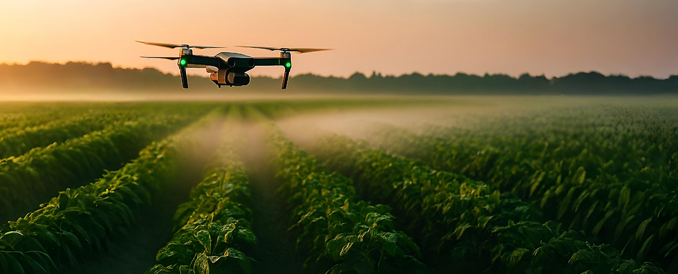
Crop Spraying
Precision drones deliver pesticides and nutrients evenly across every row, ensuring consistent coverage without oversaturation. This targeted approach reduces chemical overuse, protecting both the environment and your budget. By minimizing manual labor, it speeds up operations and allows for more frequent, accurate applications.

Crop Monitoring
High-resolution imaging and multispectral sensors identify early-stage diseases, pests, or nutrient deficiencies before they become widespread. Farmers can act quickly, preventing costly losses and improving overall crop health. Regular monitoring creates a detailed record of field conditions, enabling long-term planning and yield optimization.

Irrigation Planning
Drones map moisture levels to reveal dry spots or areas receiving excess water, which are often invisible from ground level. These insights allow farmers to fine-tune irrigation schedules and equipment for maximum efficiency. Optimized watering conserves water resources, lowers operational costs, and promotes healthier plant growth.

Livestock Monitoring
Aerial surveillance tracks herds across large pastures or rugged terrain without disturbing the animals. Drones can identify missing or injured livestock and monitor grazing patterns for better land management. This real-time insight improves herd safety, reduces manual effort, and increases operational efficiency.
"Our yield improved dramatically, and we cut pesticide use by 30%. These drones changed our season."
Mr. Singh, Farmer, Punjab
"The irrigation insights saved thousands of liters of water and improved soil health."
Ms. Khan, AgriTech Specialist, Gujarat
"From spraying to monitoring, the efficiency gains have been extraordinary."
Mr. Reddy, Farm Manager, Tamil Nadu
"The multispectral imaging revealed crop stress days before it became visible—revolutionary for early intervention."
Dr. Harish Menon, Agricultural Scientist, Kerala
Precision Spraying – Adjustable nozzles for targeted application
Multispectral Cameras – Detect crop health at the cellular level
Autonomous Flight – GPS-guided for centimeter-level accuracy
Irrigation Insights – Identify water stress before damage occurs
Compact & Portable – Foldable design for easy transport


High-Rise Buildings
Paint modern facades safely with no scaffolding required.

Bridges &
Flyovers
Apply rust-resistant coatings in hard-to-reach spots.

Industrial Tanks & Chimneys
Maintain safety compliance with minimal downtime.

Heritage
Sites
Delicate preservation through non-invasive spray.
From Takeoff to Insights

ISO 9001:2015

FAA-Approved Systems

BIS-Certified Tech Partners

4.9/5 rating from 3,200+ verified users
.png)
.png)
01
1. Farm Assessment & Planning
Our agritech experts conduct a comprehensive review of your soil quality, crop types, and terrain conditions to understand your farm’s unique challenges. They discuss your yield goals and operational priorities to craft a personalized drone strategy. This ensures every flight is optimized for maximum efficiency and results.
2. Drone Deployment
Once the plan is approved, our drones follow GPS-optimized routes tailored to your fields’ layout and crop density. They can adapt mid-flight to changing weather or unexpected obstacles, maintaining precision throughout the mission. This adaptive approach reduces waste, conserves resources, and improves coverage accuracy.
.png)
02
.png)
03
3. Data Capture & Analysis
During each flight, high-resolution cameras and advanced sensors collect detailed imagery and multispectral data. Our AI-powered platform analyzes these inputs to uncover trends like water stress, pest infestations, or nutrient deficiencies. These insights empower you to take proactive measures before minor issues become major problems.
4. Report & Recommendations
We compile findings into secure, easy-to-read reports with side-by-side comparisons of crop health, yield forecasts, and actionable next steps. Farmers can view interactive maps, charts, and alerts through our intuitive dashboard. These insights help you make confident, data-driven decisions quickly.
.png)
04
.png)
05
5. Monitoring & Optimization
After implementation, we continue monitoring your fields to track progress and detect emerging challenges early. Performance metrics are reviewed over multiple growth cycles to fine-tune spraying, irrigation, and resource allocation. This ongoing optimization ensures your farm stays competitive, sustainable, and high-yield over time.

_2344x1414_edited.jpg)
Understand Your Vision: We start by learning your event goals, venue layout, and the kind of visual story you want to create — romantic, brand-focused, or national celebration. This step ensures your aerial show fits perfectly with your theme and audience.

STEP 1
Surface Assessment

STEP 2
Paint Selection

STEP 3
Drone Execution

STEP 4
Quality Check

STEP 5
Reporting
Our team evaluates the building’s surface, structure type, and environmental factors. This helps us determine paint quantity, access angles, and safety zones — ensuring zero guesswork and full precision.
Choose from a curated range of eco-friendly, high-adhesion, weather-resistant paints tailored for your specific application — including heat-resistant, anti-corrosion, or low-VOC formulas.
Our drones are launched with pre-mapped flight paths and spray precision enabled by AI. They apply consistent coats without scaffolding, cranes, or human risk.
Post-application, we run AI-assisted visual scans and manual inspections to ensure full coverage, color consistency, and coating thickness as per industrial standards.
You receive a digital completion report with high-resolution before-and-after images, a flight path overview, and technical performance metrics.


Why Farmers Choose Laputa


Maximized Yields: Boost productivity with precision resource use.
Eco-Friendly Farming: Reduce chemical runoff and environmental impact.
Cost Efficiency: Save labor, fuel, and water with targeted operations.
Faster Decisions: Real-time insights mean quick, informed action.
Scalable Solutions: From small events to large productions.
Farmers & Experts Speak
Real stories. Real results. Real impact.
Practical Applications for Every Farm
Smarter Agriculture, Better Yields
Laputa’s Agricultural Drones Service empowers farmers to make data-driven decisions. Our drones provide precision spraying, multispectral imaging, and real-time irrigation insights, ensuring every drop of water and every pesticide spray is used effectively. Fully DGCA-compliant and AI-enhanced, they’re designed to scale from small organic farms to sprawling commercial fields.

.png)
.png)
